About Kananaskis Trail Map
A topographical map of Kananaskis Country, Alberta, Canada. The trails on the map include Burstall Pass, Chester Lake, Rawson Lake, Elbow Lake, Ptarmigan Cirque, Nihahi, Moose Mountain, and Ribbon Falls. - Search or browse
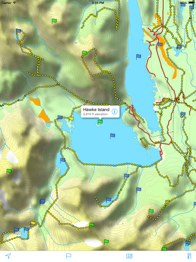
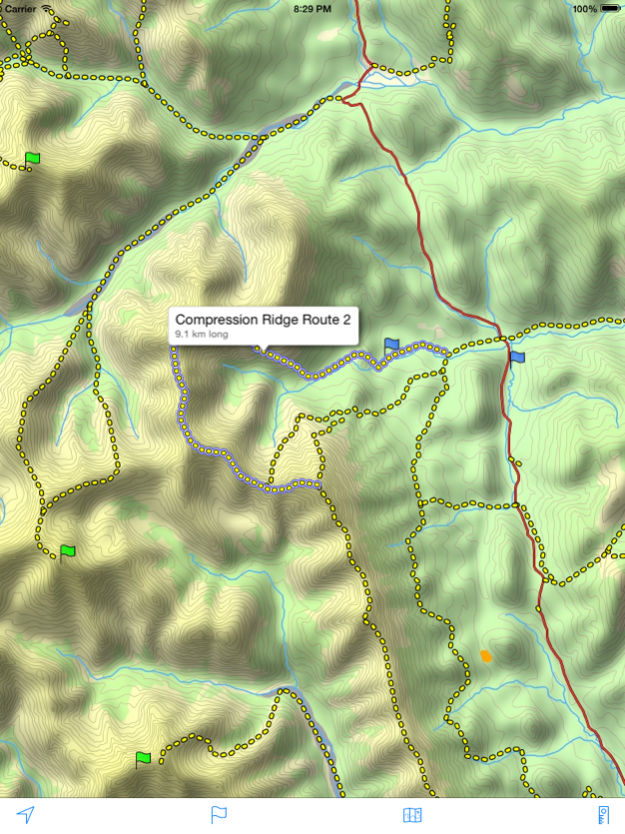
A topographical map of Kananaskis Country, Alberta, Canada.
The trails on the map include Burstall Pass, Chester Lake, Rawson Lake, Elbow Lake, Ptarmigan Cirque, Nihahi, Moose Mountain, and Ribbon Falls.
- Search or browse the names of trails, mountains, lakes, rivers, creeks, and backcountry campgrounds.
- Track your current location and elevation with GPS (on devices with a GPS receiver).
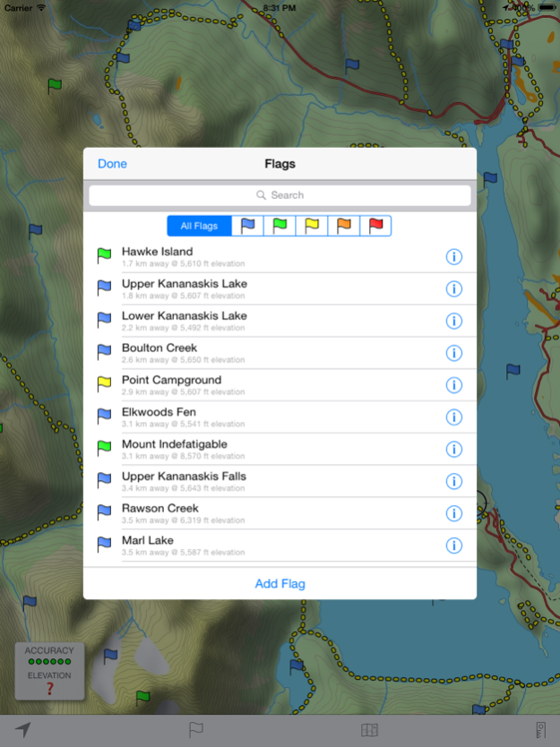
- Add flags (waypoints) to mark locations, including your current location and elevation.
- Share flags with others using email or message.
- Measure distance by sliding finger across the map.
- Use the map with no Internet connection. The entire map is stored on your device.
Note: This is an unofficial map and is not endorsed by the Government of Alberta.
Jun 2, 2015
Version 4.0
This app has been updated by Apple to display the Apple Watch app icon.
- Higher resolution maps
- Additional trails
- Trail title and length displayed by tapping anywhere along a trail
- Flag distance and elevation
- Support for iPad and larger iPhones
Previous Versions
Here you can find the changelog of Kananaskis Trail Map since it was posted on our website on 2016-09-25 00:58:42.
The latest version is 4.0 and it was updated on 2024-04-22 08:46:39. See below the changes in each version.
Kananaskis Trail Map version 4.0
Updated At: 2020-06-02
Changes: 2. Juni 2015 Version 4.0
- Higher resolution maps
- Additional trails
- Trail title and length displayed by tapping anywhere along a trail
- Flag distance and elevation
- Support for iPad and larger iPhones
Kananaskis Trail Map version 4.0
Updated At: 2015-06-02
Changes: Jun 2, 2015 Version 4.0
This app has been updated by Apple to display the Apple Watch app icon.
- Higher resolution maps
- Additional trails
- Trail title and length displayed by tapping anywhere along a trail
- Flag distance and elevation
- Support for iPad and larger iPhones
Kananaskis Trail Map version 4.0
Updated At: 2015-06-02
Changes: 2 Jun 2015 Version 4.0
This app has been updated by Apple to use the latest Apple signing certificate.
- Higher resolution maps
- Additional trails
- Trail title and length displayed by tapping anywhere along a trail
- Flag distance and elevation
- Support for iPad and larger iPhones
Kananaskis Trail Map version 4.0
Updated At: 2015-06-02
Changes: Jun 2, 2015 Version 4.0
- Higher resolution maps
- Additional trails
- Trail title and length displayed by tapping anywhere along a trail
- Flag distance and elevation
- Support for iPad and larger iPhones
Kananaskis Trail Map version 4.0
Updated At: 2015-06-02
Changes: Jun 2, 2015 Version 4.0
This app has been updated by Apple to use the latest Apple signing certificate.
- Higher resolution maps
- Additional trails
- Trail title and length displayed by tapping anywhere along a trail
- Flag distance and elevation
- Support for iPad and larger iPhones
Kananaskis Trail Map version 4.0
Updated At: 2010-02-03
Kananaskis Trail Map version 4.0
Updated At: 1970-01-01
Changes: 2 de jun. de 2015 Version 4.0
This app has been updated by Apple to use the latest Apple signing certificate.
- Higher resolution maps
- Additional trails
- Trail title and length displayed by tapping anywhere along a trail
- Flag distance and elevation
- Support for iPad and larger iPhones
Kananaskis Trail Map version 4.0
Updated At: 1970-01-01
Changes: 2015年6月2日 Version 4.0
This app has been updated by Apple to use the latest Apple signing certificate.
- Higher resolution maps
- Additional trails
- Trail title and length displayed by tapping anywhere along a trail
- Flag distance and elevation
- Support for iPad and larger iPhones
Kananaskis Trail Map version 4.0
Updated At: 1970-01-01
Changes: 2015년 6월 2일 Version 4.0
This app has been updated by Apple to use the latest Apple signing certificate.
- Higher resolution maps
- Additional trails
- Trail title and length displayed by tapping anywhere along a trail
- Flag distance and elevation
- Support for iPad and larger iPhones
Disclaimer
Official App Store Link
We do not host Kananaskis Trail Map on our servers. We did not scan it for viruses, adware, spyware or other type of malware. This app is hosted by Apple and passed their terms and conditions to be listed there. We recommend caution when installing it.
The App Store link for Kananaskis Trail Map is provided to you by apps112.com without any warranties, representations or guarantees of any kind, so access it at your own risk.
If you have questions regarding this particular app contact the publisher directly. For questions about the functionalities of apps112.com contact us.